*THE WAITAPU, DUAL CIRCLE STANDING STONE OBSERVATORY. *
Throughout the ancient world, in many climes, one of the most common ways of preserving the profound astronomical, navigational and calendar knowledge was to encrypt it into the dimensions of temples and significant community buildings -- or into the positions of standing stones.
In 1997 I took my building site surveying equipment to the Waitapu Standing Stone Observatory in Northland, New Zealand and initially spent two weeks recording the positions of the fallen stones. I'd started out assuming that a particularly large sharksfin shaped stone was a hubstone and that lines emanated out from it like spokes. After a few days of trying to take theodolite fixes from that position, I had to abandon it, scrap my field notes and start again. The chosen hub almost worked, but enot quite and I came to find out that the true southern hub was a large squat, wide based boulder only 7-feet SSE of the initially chosen stone. From the moment I set the theodolite up at the correct position it became apparent that everything was beginning to gel and make proper sense for the first time.
Between 1997 to 1999 I was to make many return trips to the valley, where I lived in my camper van and devoted my time to recording the positions of additional stone components on the observatory site. The information from my field notes was later entered into AutoCAD and the positions of all recorded stones were precisely plotted. I also categorised the stones into 6 groupings depending on size and shape, as well as noting the direction in which the stones lay in the long grass. Despite fixing the positions of about 700 component stones over the years, the task was never fully completed as many large stones, residing at downhill positions to the east or south, lay in thick bracken and overgrowth. These peripheral markers were very difficult to get a fix on, without cutting back and clearing foliage. Inasmuch as the land was administered by the New Zealand Department of Conservation, I had no authority to interfere with plant regeneration and so was obliged to miss those positions in my surveys.
.......
*SO, WHAT WAS THE SITE FOR?*
As has been demonstrated in part, the ancient people were encoding their astronomical, navigational and calendar numbers into the landscape over vast distances of regional terrain and much of the work undertaken resolved back onto the hubstones of the Waitapu Observatory. The Observatory itself served the function of coding the great numbers of antiquity in miniature within the confines of the site. This it did by way of both a distance and degree angle to a standing stone marker situated at an outward position from the hubstones. Coupled with that were particular markers, which coded PHI, PI or the angles found within a specialised sacred geometry overlay system that was used universally throughout the ancient world by the great civilisations.
The Waitapu Observatory site served the function of a "School of Learning", where the brightest children from hamlets all over ancient New Zealand were introduced as initiates. Through long years of intensive study by adept masters these gifted students learned the astronomical and navigational arts before returning to their home regions, where they taught the age-old mathematical principles or set up surveying systems and observatories.
The Waitapu Valley School of Learning was, by no means, the sole educational facility where this kind of activity was going on in ancient New Zealand. There were many regional centres, satellites and outposts throughout the country where cairn markers are still clearly in evidence and many such locations also had "Schools of Learning". The Waitapu Valley remains, however, the largest centre for this kind of activity that we have, as yet, encountered.
I offer the following findings as a precursor to some future, more refined and detailed analysis by professional archaeologists, using the best equipment and methodologies available to the scientific community. As stated, we cannot be absolutely certain of precise original positions until a careful archaeological assessment and restoration takes place. This shouldn't prove to be too difficult, but will need to be done with all due care, as each position is a coded distance and angle from the hubstones. The profound astronomical/ navigational/ measurement standard/ cyclic and calendar knowledge of antiquity is locked into this site and it is the same system as is found from Egypt to Britain to the Americas and down into Oceania.
Please know this with absolute certainty -- the dormant knowledge reposing in the Waitapu Stone Observatory has the potential to open up and restore lost astronomical/ navigational/ calendrical knowledge worldwide and tell us why our very migratory, highly mobilised forebears raised standing stone and cairn markers in many locations throughout the world -- including here in the distant Isles at the ends of the Earth.
Let's now begin the tedious task of unravelling some of the site, stone by stone. This will be a laborious exercise, which cannot be circumvented if we are to understand the workings of this very ancient New Zealand observatory and the dormant knowledge that sleeps within it.
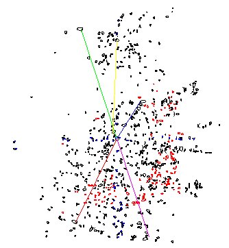
*Figure 1: This picture shows the distribution of most stones to be found within the confines of the Waitapu Observatory.
The numbered stones going north, south, east and west are the only ones we'll discuss at this point in time. The red stones represent "missed positions" that were detected while testing a theory about "zodiac markers". The lines shown run to particularly large stones, for which some analysis is proffered in the following text.*
*Please keep it in mind that the following "discussed" sampling is arbitrarily chosen for convenience and any stone on site could be similarly assessed.
Please know also that all on-site surveys were done in metric measurements, as my very long, non-stretchable fibreglass tape measure is calibrated solely in metres and centimetres. I therefore had no idea what the measurements would translate to while in the field. I later entered all coordinates into AutoCAD, according to metres and only after subjecting the plotted positions to upward rescaling of 1: 3.2808398 did the measurements in inches, feet, cubits, reeds, etc., become apparent. There was no forced manipulation of positions to fit some preconceived paradigm or theory.*
........
*A SAMPLING OF STONE MARKERS TO SHOW HOW THE WAITAPU OBSERVATORY WAS USED -- GOING NORTH.*
Stone 1. This is the southern hubstone from which all fixes in this section will be taken.
Stones 2 & 3. These stones are a double set that stood on each side of a line that ran to true north. Their positions are 14 feet from the hub and if standing they would be 6 inches apart. They would also have coded 14.4 feet (172.8 inches) and have related to a very prominent navigational code.
Stone 4. This is a large oval stone and its size designates its importance. It appears to mark the distance of 20.736 feet or 248.832 inches. This is 12 Egyptian Royal Cubits of 1.728 feet (20.736 inches) or 6 Aztec Hunabs. The boulder's inch distance value codes the circumference of the Earth under the Egyptian "true" equatorial measurement of 24, 883.2-miles. Also, 12 Royal Cubits of 20.61818182 inches ("6" series) or 20.625 ("11" series) would equally be inferred and marked onto the oval crest of this stone, which originally ran north-south. Another oval boulder of similar dimensions was used as a station for getting a fix on east, which was marked by a geological feature in the distance.
Stone 5. This is a medium large stone that undoubtedly sat 24.8832 feet and 3.3-degrees east of the hubstone. Its position coded the circumference of the Earth according to 3 varied cubits and inferred 24883.2-miles (true), 24750-miles ("11" series) and 24741.81818-miles (sexagesimal/ septimal). The 3.3-degrees offset relates to the "11" series lengths of leagues, miles, furlongs, chains, rods/ perches, fathoms and links, which are all fluidly divisible by 3.3 either in their foot or inch values.
Stone 6. This stone sits on due north at 28.8 feet from the hubstone. The position codes one of the biggest numbers of antiquity (288). The 288 feet code is found on the diagonal face values of the Great Pyramid (576 feet to the altar floor -- 288 X 2) and Menkaure Pyramid (288 feet...base to apex up the centre-face), as well as in the width of the Aubrey Circle at Stonehenge. The value of an Egyptian Pyramid acre was 28800 square feet, etc., etc.
Stone 7. This stone sits 68.04 feet from the hubstone and is a medium large stone, showing it to be important. It originally stood on due north and its position coded the lunar nutation cycle of 6804-days.
Stone 8. This is a medium small ground marker that sits 70 feet from the hubstone. It codes either "rounded" PHI (1.62) or pure PHI (1.6180339) in its degree angle off north.
Stone 9. This stone sits on due north at 75 feet distance. It was undoubtedly dual coded in the thickness of its girth and coded 75.6 feet on its northern face (the side length of the Great Pyramid is 756 feet or 1/8th of a minute of Earth circumference arc under the sexagesimal navigational system).
Stone 10. This stone, undoubtedly, codes two closely related numbers in its position. The first of these is 87.5 feet, which is part of the 175 mathematical progression, very important to calendar determinations and also the lunar cycle. The position would also be considered as 88 feet (possibly due to girth thickness and northern face position) and code a very important number used in navigation under the "11" series geodetic system. The value of 88-feet is 1/60th of a mile.
Stone 1B. This is the northern hubstone, situated 96 feet from (1152 inches) and due north of the southern hubstone.
Stone 11. This stone sits 101.25 feet from the southern hubstone and codes a very important ratio in its position. This ratio, used in a mathematical progression, creates numbers like 40.5 & 81, which, in a count of days, were very important to tracking the progress of the moon through 7.2 lunar years (during the 7 solar year Sabbatical Lunisolar Calendar cycle).
Position 12. This is a flat terrace or small platform upon which two markers (stones 11 & 13) once stood. Its central region sits due north of and 101.25 feet from the southern hub.
Stone 13. This stone sits 103.68 feet from the hubstone. The position is 60 Egyptian Royal Cubits of 1.728 feet, which equates to 30 Aztec Hunabs. The purpose of the stone was to act as a mnemonic device for recording the true equatorial circumference of the Earth. The inch value is 1244.16 and � the "true" equatorial circumference of the Earth was considered to be 12441.6-miles. The position would, undoubtedly, have been used symbolically to remember the circumference under the "6" and "11" series navigational systems also, as these were very close to the "true" figure, but far more convenient to use when plotting charts at sea. This stone also marked 359-degrees azimuth.
*GOING SOUTH -- WITH SOME OFFLINE DEVIATIONS.*
Stone 14. This stone codes a tremendously important number in its position, which was 11.52 feet. The number was "multi-use" in antiquity and was pressed into service for everything from navigation to correcting the Sothic Year from 365.25-days to 365.2420-days (by deducting 11.52 minutes under the Sumerian/ Babylonian chronology system that was adopted universally and persists into modern times).
Stone 15. This is a very important position that positively codes the lunar cycle in both distance and azimuth degree angle. The distance is 11.8125-feet and the azimuth angle is 170.1-degrees. On the Khafre Pyramid, which was built according to a 3,4,5 triangulation formula (3,4,5 squaring method) the basic unit was 118.125-feet (which in days was 4 lunar months). Therefore � the base length was 3 X 118.125 feet (354.375-days is the lunar year), the height was 4 X 118.125 feet (472.5 feet) and the side diagonal length was 590.625 feet (� this number is 295.3125 feet & the lunar synodic month is 29.53125-days). The azimuth angle of this stone position at Waitapu Observatory is 170.1-degrees, coding 1701-days, which is 1/4th of the 6804-day lunar nutation cycle (major standstill of the moon till major standstill of the moon -- 18.613-years).
Stone 16. This stone codes 30.24 feet in mnemonic reference to the 3024 feet perimeter of the Great Pyramid (� a minute of Earth circumference arc under the "6" series navigational system. The position would also have coded 30.25 feet in reference to the "11" series (league, mile, furlong) system of navigation. The azimuth angle is 180-degrees.
Stone 17. This stone would have been dual coded -- 31.5 feet to its north face and 32 feet to its south face. The 31.5 distance is an expression of the reed measurement (10.5 feet) and this distance is 3 reeds. The internal circuit of the Sarsen Circle at Stonehenge is 315 feet or 30 reeds (� a Greek stadia). One side of the Great Pyramid's base (756 feet) would be 24 X 31.5 feet. The 32 feet increment was equally important and much used by the "Mound Builders" of North America. The azimuth angle is, again, 180-degrees. Any time that the 31.5 number occurs it is also inferring PI at 3.1416 and this code reposes in the position of the stone. The internal circuit of the Sarsen Circle at Stonehenge also meant 314.16 feet.
Stone 18. This stone sits at 38.4 feet from and due south of the hubstone. The number 38.4 is part of a mathematical progression leading to 1152 and 5184 -- used in navigation. The southern face of the stone, undoubtedly coded 39 feet (3 X 13) and related to the ancient Sabbatical Calendar, which had 13 months in the year (of 28-days each) in its raw count. It was allowed to run for 7 solar years (Sabbatical Year) before correction (8.75 days) during a festival.
Stone 19. Again, this stone would have been dual coded. Its northern face was 43.2 feet from the hubstone or 518.4 inches. The manner in which the ancient Egyptians used the perimeter of the Great Pyramid (3024 feet? -- a minute of arc) to relate to the sexagesimal circumference of the Earth was to multiply it by 43200. This was 360-degrees X 60 X 2 = 43200. The southern face of the stone was 44 feet from the hub. The overall size of the flat floor altar atop the Great Pyramid (it never had a capstone) was 44 feet per side and this increment was of extreme value in calculating the size of the Earth. The formula was: The vertical height of the pyramid to its altar floor (453.6 feet) � � the length of the altar floor (22 feet) = 20.61818182 (the sexagesimal Egyptian Royal Cubit is 20.61818182 inches) -- then multiply this figure by 1200 and read the result in miles. The same formula relates to each differing Royal Cubit (PHI -- or 11 series, for which the pyramid had marginally different height assignments, which varied a few inches less and more from the above reading).
Stone 20. This stone does virtually the same as its companion nearby, except its azimuth angle is 182.625-degrees, which, in days, is � the solar year or the time between recurrences of the equinox. Some ancient Maori moko's (full facial tattooing) showed 13 dark stripes and 14 light stripes (from eyebrow to eyebrow) across the forehead. By multiplying 13 X 14 (bi-weeks) one gets 182-days, which is the number of full days between equinoxes. The art of moko was learned, by Maori, from the more ancient inhabitants, who are called Patu-pai-arehe or "Stone Builders" in Maori oral traditions.
*Figure 2: A scene that took several years to finally photograph. We tried on several occasions to capture the equinox sunrise on the Tutamoe Range, as seen from the Waitapu Observatory, but were always defeated by thick cloud cover. The large dip to the right of the sunrise position is the "V", which provides a perfect easting from a marked position on the observatory. This azimuth angle would be the equinox line from a beach, when watching the sunrise over the sea horizon (east...90-degrees). At Waitapu observatory one has to wait an additional 20-minutes beyond the sun's sea horizon rise to finally see it emerge behind the elevated Tutamoe Range. The sun comes up at a severe angle and moves left as it rises, finally emerging at this point of the range, as seen from the Waitapu Observatory. Ancient astronomers throughout New Zealand used their local terrain in a similar vein, by knowing which day was the equinox and where the sun would emerge on the skyline. Such a system existed in the Auckland Isthmus, where observations from Stockade Hill toward a "V" cut in the summit crest of Mount Wellington (sunset) or from Mount Albert toward the same "V" cut in the crest of Mount Wellington (sunrise), designated the day of the equinox... (Photo courtesy of Deborah Pyke).*
Stone 21. This stone lies due south of the hubstone at a distance of 46.08 feet. The number is part of an 11.52 mathematical progression (11.52 X 4), used in navigation, where the circumference created by a linear league travelled equated to 51840 feet.
Stones 22 & 23 were probably meant to convey 48 feet (multi-use sexagesimal number) and 48.6 feet (lunar & Sabbatical Calendar number) respectively. They sat at 182-degrees and coded both 364-days (raw count year -- 13-months of 28-days under the Sabbatical Calendar system) and 365.25-days (true year) in their half values.
Stone 24. This stone sits at 60 feet from the hubstone and the azimuth angle remains 182.625-degrees.
Stones 25 & 26. Stone 25 sits 63 feet from the hubstone or 1/10th of a Greek Stadia of 630 feet. It would make sense if this stone was originally placed at an azimuth angle of 175-degrees (important ratio of the septimal series), which it almost does. Stone 26 was undoubtedly meant to stand at 64 feet from the hubstone at an angle of 176-degrees (navigation in the "11" or league, mile, furlong series).
Stone 27. This stone sits at 68.04 feet and at an azimuth angle of 182.625-degrees. The 68.04 feet is in remembrance of the 6804-day lunar nutation cycle encoded into the Khafre Pyramid (Egypt's pyramid of the moon).
Stone 28. Probably once sat at an azimuth angle of 181.44-degrees and 69.12 feet from the southern hubstone. This distance is 40 Egyptian Royal Cubits of 1.728 feet or 20 Aztec Hunabs of 3.456 feet. This degree angle also would be read as 181.5 and produced a number very important to navigation under two systems, which will be explained as we proceed.
Stone 29. This seems to be a repeat of the distance of stone 28, but the azimuth angle is 176-degrees (navigation under the "11" series).
Stone 30. Again the standing position of this stone appears to be 40 Egyptian Royal Cubits of 1.728 feet each. The degree angle seems to be coding the difference in size between a "Royal" cubit and a "common" cubit. The Egyptian Royal Cubits each had a "common" counterpart that was 1.166666 in ratio less. Thus the associated common cubit to a 1.728 Royal Cubit (20.736 inches) was 17.7737 inches. The azimuth angle appears to be coding 177.7-degrees.
Stone 31. Appears to be 40 Egyptian Royal Cubits from the hubstone and at an azimuth angle of 179-degrees.
Stone 32. This large stone was probably dual coded and represented 77 feet on its north side and 77.76 feet on its south side or apex. The 77.76 feet is 45 Egyptian Royal Cubits of 1.728 feet or 22.5 Aztec Hunabs. It's also 28.8 rounded Megalithic Yards of 32.4 inches. The true Megalithic Yard was a PHI based measurement of 32.360678 inches (1.6180339 X 20) and pure PHI would have been inferred in this measurement. The stone probably sat due south of the hubstone.
Stone 33. This stone probably sat at 178.2-degrees azimuth and 81 feet of distance from the hubstone. The degree angle is in deference to the Menkaure Pyramid, which was built according to an ancient fathom of 5.5 feet, for a full side length of 356.4 feet (178.2 X 2 feet or 32.4 fathoms). The 81 feet distance is related to 324-1/4th. The Menkaure Pyramid had both a fathom assignment and a pure PHI assignment, which was duplicated on the "Y" Holes Circle at Stonehenge. "Y" Holes (178 feet) was a PHI reduction of the Aubrey circle (288 feet). The 81 feet attributable to this stones position is 30 "rounded" Megalithic Yards of 32.4 inches. It can also be (symbolically/ literally) read as 32 true (PHI based) Megalithic Yards of 32.360678 inches (80.09165 feet). The "81" code also symbolises � PHI at .80901695 and the "Megalithic Rod" proposed by Professor Alexander Thom had a true length value of 80.90165 inches.
As complex as this might sound, the stone position (in both distance and degree angle) was coding PHI and rounded PHI knowledge. This same encoding is found at the ancient Octagon earth-mound complex of Newark, Ohio, USA, as elsewhere around the ancient world.
Stones 34 & 35 seem to be a part of a "double set" of related markers. There are several examples of this form of positional marking on the site and they probably relate to "crossing geometry" on the observatory. The important code related to this position sits between the two closely situated stones at 82.5 feet from the hubstone and at an azimuth angle of 176-degrees. The 82.5 feet is an important incremental value in a mathematical progression related to the furlong, mile and league. This increment is 1/8th of a furlong or furrowlong (660 feet), 1/64th of a mile (5280 feet) or 1/200th of a league (16500 feet). It is also 5 rods/ perches (16.5 feet), 15 fathoms (5.5 feet) or 125 links (7.92 inches). In both the length and azimuth angle (176-degrees) the values relate to the "11" series of lengths and 176 is 1/30th of 5280 (mile). There are 1760 yards in a mile and one of the encasing circles of the Crosshouse at Miringa Te Kakara in New Zealand was 176 feet (related to the "11" series geodetic system).
Stone 36. To understand the significance of the position of stone 36 one has to understand the "6" and "11" series coding of the Great Pyramid and how it relates to the size of the Earth. The azimuth angle to this position (like stone 28) was intended to convey 181.44-degrees. This figure X 2 = 362.88 and the inch perimeter value for the Great Pyramid is 36288, which distance is also � a minute of Earth circumference arc. This Waitapu Observatory azimuth angle can also be read as 181.5-degrees (X 2 = 363). Under the Great Pyramid's "11" series full perimeter reading (league, mile, furlong) it was considered to be 36300 inches (12 inches longer) and this meant the Earth's size could be read in the very convenient "11" series increments -- perfect for navigation, where a linear distance travelled in "leagues" would convert to a sexagesimal circumference. By this ingenious method of plotting a ship's course, degree angles from point of departure to destination could always be known, despite many course changes.
The distance that this stone sits from the hubstone is 84 feet, which is 1/36th of the perimeter value of the Great Pyramid under its sexagesimal (true) assignment. In its inch value, 84 feet is 1008 inches and 100.8 feet was 1 second of arc for the Earth under the sexagesimal geodetic system. One of the official internal diameter measurements of the Sarsen Circle at Stonehenge is 100.8 feet, or one second of Earth circumference arc.
Stone 37. This important position was, undoubtedly, dual coded and related to a distance of 84 feet and 84.375 feet simultaneously. The value of 84.375 is a mathematical progression that produces lunar cycle values and useful numbers for reading the moon's progress during the Sabbatical Calendar period of 7.2 lunar years or 2551.5-days. Again, the azimuth angle is 176-degrees and relates to the "11" series geodetic system.
Stone 38. This stone was undoubtedly dual coded in the distance to its north and south faces. The distance to its north face was intended to code 85.05 feet, which is � of 170.1 feet. The lunar nutation cycle endured for 6804-days, which is 1701-days X 4. The lunar nutation cycle was, therefore, calibrated to 80 periods of 85.05-days. The true cycle (18.613-years) is 6798.36-days -- but this number will not work in a mathematical progression, so 6804 was pressed into service to describe the cycle. Minor corrections could be made at the end of each lunar nutation cycle and locked onto the midwinter solstice. An example of the repetitive use of 1701 is found at the Octagon of Newark, Ohio, where the number is positively encrypted into the dimensions of the site.
The other distance code in this stone's position is 86.4 feet (south face). The sun's diameter is 864,000 miles and there are 86400 seconds in a day. The Ninevah constant number, found by George Smith in 1875, as inscribed onto a clay tablet in Ninevah, was 195955200000000. This is a mathematical progression total that can be based upon 864000 X 226800000 (3 sides of the Great Pyramid perimeter were 2268 feet). The perimeter of the Great Pyramid was also 35 X 86.4 feet (3024 feet). This important stone sat due south of the hubstone.
Stone 39. This position was probably quadruple coded to convey at least 4 numbers or ratios and is a good example of how intensive the ancient coding systems were. It undoubtedly meant 90.72 feet, 90.75 feet and 91.2384 feet, as well as 91.33333 feet. The first 3 numbers relate to the 3 main types of Egyptian Royal Cubits in use -- the "6" series (20.61818182 inches), the "11" series (20.625 inches) and the largest at 1.728 feet or 20.736 inches. As has been stated, each Cubit carried an individual code for calculating the size of the Earth. In this instance, the position of the stone represented 52.8 Royal cubits (remember, there are 5280 feet in a mile -- also the top floor altar of the Great Pyramid was 44 feet long or 528 inches, etc.). The fourth code seems to suggest 1100 inches (91.3333 feet) and relate to the 11 series distances.
The azimuth angle tends to allude to the "Cubits" also, as each Egyptian Royal Cubit had a "common" counterpart. The formula for calculating the size of a "common" cubit was to divide the "Royal" by 1.16666666. On the Royal Cubit of 20.736 feet the common equivalent was, therefore, 17.7737 inches. The azimuth angle of this stone appears to be very close to 177-degrees and probably was for mnemonic reference to the "common cubits". The selfsame formula was applied to the Hebrew/ Celtic Royal Cubits of 21 inches, where their "common" equivalents (21 � 1.1666666) were 18 inches. The Egyptians used these larger cubits (21" & 18") also and the Great Pyramid is 432 X 21 inches per side or 504 X 18 inches per side (756 feet).
Stone 40. This stone is dual coded in terms of its north and south faces. The first code is 92.16 feet or 11.52 feet X 8. The second code (93.33333 feet -- south face) relates to the important number 56. Also, there's reference to the Menkaure Pyramid in pure PHI and rounded PHI expressions by the stone's azimuth angle of 178.2-degrees (Menkaure was 356.4 feet or 132 rounded Megalithic Yards in length per side -- 178.2 feet X 2 or 528 rounded Megalithic Yards for a full circuit). If Menkaure's length was read symbolically by pure PHI based Megalithic Yards, then its side length was exactly twice the diameter of "Y" Holes at Stonehenge, with its diagonal face length being exactly the diameter of the Aubrey Circle at Stonehenge (288 feet).
The distance, at 93.33333 feet (1120 inches) is 1/6th of 560 feet. Under the solar calendar counting system the count was done through 56 positions (thus 56-posts on the Aubrey Circle at Stonehenge). The lunar count also worked well on 56 positions (thus the ancient system adopted by lunarists of 28 lunar mansions). The moon also worked well to 54 counted positions in the 6804-day cycle. The 1120 inches also alludes to the hundredweight (CWT) system (20 CWT in a ton) that originated in Egypt and became the British weights system. The Great Pyramid is 32.4 increments of 1120 inches in perimeter length -- in other words it's perimeter circuit is 1120 rounded Megalithic Yards.
Stone 41. This marker once sat exactly 96 feet from and due south of the southern hubstone, which was 96 feet from the northern hubstone. If circles are sent out from each hubstone that exactly cross the epicentre of the opposite hubstone, then the effect created on the site is 3 sections of 96-feet each -- or 288 feet. The Aubrey Circle at Stonehenge was 288 feet in diameter, as was the intended, designed, diagonal face length of the Menkaure Pyramid.
*GOING EAST -- WITH SOME OFFLINE DEVIATIONS.*
Stone 42. This stone has been radically moved away from its original position and its very close proximity to the hubstone makes it an impossible object to realistically assess.
Stone 43. This stone is undoubtedly dual coded in consideration of its western and eastern faces. Its western face coded 8.505 feet and related to a mathematical progression within the lunar nutation cycle of 6804-days. The eastern face coded 8.8 feet and alluded to an important increment in the "11" series navigational system. This distance is 105.6 inches. The diameter of the circle component of the Octagon of Newark Ohio was 1056 feet from crest to crest across the circle embankments (ref. Marshall), as was the "crest" circumference of the outer embankment beyond the Aubrey Circle at Stonehenge. The azimuth angle of this stone also relates to the "11" series navigational system inasmuch as it is 99-degrees and an important number in a progression leading to 7920 (the league circumference of the Earth).
Stone 44. This stone seems to be set to 11 feet on an azimuth angle of 99-degrees. It seems reasonable to assume that it also coded 11.2 feet and 11.52 feet.
Stone 45. This stone is dual coded and refers to at least 2 things in its placement. Its primary code is 13.125 feet from the hubstone at an azimuth angle of 99-degrees. The 1.3125 ratio is one of the foremost in use in antiquity and is both a "reed" & "lunar" mathematical progression simultaneously. The once much used reed measurement was 10.5 feet and the likelihood is that most staffs (rods) carried by ancient priests were fashioned in � reeds (5.25 feet) and calibrated for measurement. One could use a reed staff to effectively calculate the position of the sun or moon for any date within the 7.2 lunar year/ 7 solar year Sabbatical Calendar system. The reed measurement also worked extremely well in fixing the position of the moon for any day during the 6804-day lunar nutation cycle. It's probable that the stone was also used for mnemonic reference to the true size of the Earth under the Egyptian system of 131383296 feet. The azimuth angle remains 99-degrees.
Stone 46. This stone sits due east of the hubstone and codes 31.416 feet (PI) and 31.5 (stadia related) simultaneously. The stadia (630 feet) was designed to be in increments expressing a very close relationship to true PI (3.1416). The 3.15 expressions, or "rounded" PI, were a similar concept to the "rounded" PHI increments based upon 1.62 (1.6180339 true) used in the Megalithic Yard measurement (32.4 inches "rounded" or 32.360678 inches true).
The ancient designers of the Egyptian system of Metrology attempted to fashion it as close as possible to true PI and PHI, without the necessity of using the very cumbersome numbers produced by using the pure expressions. Because of this close compliance to true PI & PHI, the Great Pyramid can easily be read or calibrated according to pure PI or PHI expressions. Examples of this relate to something as simple as the side length (756 feet), which is either 240 increments of 3.15 feet or 280 Megalithic Yards of 32.4 inches each. This left the option open to symbolically read the Pyramid in "pure" expressions of PI & PHI, to which it complies admirably. An example of this is � its base length (378 feet) X PHI (1.6180339) represents its diagonal side length (611.6168142 feet), where lines running up the centre faces would intersect above the altar floor (there never was a capstone -- only a symbolic one that featured in the pyramid's geometry).
Stone 47. This stone is 34.56 feet from the hubstone on an azimuth angle of 90-degrees. This length is 10 Aztec Hunabs or 20 Egyptian Royal Cubits of 20.736 inches. This particular cubit was used as a memory device to always remember the "true" size of the Earth at 24883.2 miles circumference. The distance of 34.56 feet would also be 1/10th of Stonehenge's Sarsen Circle outer rim circumference. This number had great significance within the coded parcel of "sacred" numbers and will recur very frequently in lengths and angles on ancient structures worldwide. The angle from the "benchmark cleft", on the southern Waitapu Valley's seaward cliff to its level trig boulder on the northern hillrise, is 345.6-degrees azimuth at a distance of 2268 feet (lunar code).
Stone 48. This stone sits 44 feet from the hubstone at an azimuth angle of 88-degrees. The altar on the top of the Great Pyramid was 44 feet (528 inches) and its relationship to the altar height was used to calculate the circumference of the Earth according to several numerical systems. The 88-degrees azimuth co-relates with 44 feet to accentuate the "11" series navigational system.
Stone 49. This stone is very important and sits at a distance of 51.84 feet from the hubstone. The side angle of the Great Pyramid is 51.84-degrees. The base area that the Great Pyramid occupies is 5184 reeds. The total area of the "flat topped" Great Pyramid's 4 faces and base is 51.845 Egyptian Pyramid acres of 28800 square feet each (identified by Herodotus). The Octagon of Newark, Ohio lies on an azimuth angle of 51.84-degrees. The circumference of a circle based upon the diameter of 1 ancient league of 16500 feet is 51840 feet. One fifth part of the precession of the equinoxes is 5184 years, etc. This stone sits due east of the hubstone.
Stone 50. This stone sits due east of the hubstone at 58.33333 feet, which was a very important number in ancient calculations, based upon 1/3rd of 175. If the degree angle of the Great Pyramid (51.84) is multiplied by 58.33333, the result is 3024 -- the perimeter distance around the base of the Great Pyramid.
Stone 51. This position represents a cut step or platform in the inclined ground falling away to the east. There are many of these carefully fashioned platforms, the fronts of which are reinforced by stones to ensure the platform's longevity. I have marked many platforms on my AutoCAD representation in this exact manner. Generally, the stones, which once sat on these platforms, have been tumbled forward and lie at the base, often in overlaying bunches. The centre region of this small platform sat due east of and 60 feet from the hubstone.
Stone 52. There is a tumbled array of stones lying at the foot of the platform, one or two of which were unceremoniously shoved there from above. It's thought that one of the stones, formerly on the platform, would have coded 59.0625 feet (lunar-half of 59.0625 is 29.53125 -- the lunar month in days) and another 60 feet. Other stones at the front would have coded 62.5 feet (navigation under the "11" series) and 63 feet (reed & stadia). The stones lie, more or less, due east of the hubstone.
Stone 53. This stone sat due east of and 72 feet from the hubstone. The value of 72 feet (864 inches) is one of the most important in the "6" series (sexagesimal).
Stone 54. This is another cluster of former standing stones in disarray. They sit at a distance of 75 feet from the hubtone on due east. One of the positions would have represented 75.6 feet in mnemonic reference to the base length of the Great Pyramid. Beyond this point bracken encroaches upon the positions of markers and determining positions becomes quite difficult.
*GOING WEST -- WITH SOME OFFLINE DEVIATIONS.*
Stone 55. The apex of this stone probably once represented 3.456 feet (1 Aztec Hunab or 2 Egyptian Royal Cubits of 1.728 feet each) from the epicentre of the hubstone at an azimuth angle of 240-degrees. The stones very close proximity to the hub makes it difficult to assess precisely.
Stone 56. This stone sits 9.45 feet directly west of the hubstone and codes a dynamic lunar number in its inch value (113.4). The Station Stones rectangle at Stonehenge is 113.4 feet wide X 264 feet long and it regulated the slightly elliptical design width of the Sarsen Circle standing stones and lintels from 45-degrees azimuth to 225-degrees azimuth (which was 113.4 feet). The period of 1134-days is 1/6th of the 6804-day lunar nutation cycle. The value of 3 sides of the Great Pyramid is 2268 feet (756 feet per side) or 2 X 1134 feet. At Carnac, France, the western circle at the extreme end of the site, works primarily to a radius of 113.4 feet or a diameter of 226.8 feet.
The value of 9.45 feet is � of 18.9 and the 189 number was much used in all manner of ancient lunar calculations, including 7.2 lunar years (2551.5-days) within the Sabbatical Calendar system or 6804 days within the lunar nutation cycle. One side of the Great Pyramid is 189 feet X 4.
Stone 57. This stone appears to be part of a double set in conjunction with stone 55 and the degree angle coding might lie centrally between the two. The position appears to code 9.216 feet, which is part of the 1.152 or 11.52 mathematical progression. The position would also have coded 110 inches. The Sarsen Circle at Stonehenge (under its PHI reduction assignment) was 110 feet wide. This was the result of a PHI reduction on the size of "Y" Holes Circle (178 feet), which in turn was a PHI reduction on the Aubrey Circle (288 feet), etc. The intended degree angle coding for this stone's position at the Waitapu Observatory was probably 280-degrees.
Stone 58. This stone sits 12 .96 feet from the Hubstone or 155.52 inches. At the Octagon of Newark Ohio from the centre of the circle embankment to the centre of the 8 indvidual embankments forming an octagon, was 1555.2 feet or 576 rounded Megalithic Yards. The number 12960 is � of 25920 -- the number used in describing the precession of the equinoxes in years. The stone lies on the due west line of 270-degrees azimuth and probably stood on that line originally.
Stone 59. This stone sits 15 feet from the hubstone at 260-degrees azimuth. The distance and angle have a relationship to calendar calculations and the azimuth angle would also have been read as 259.20-degrees in mnemonic reference to the precession of the equinoxes number of 25920. The stone would also have coded 15.12 feet and relate to the length value of 2 sides of the Great Pyramid (1512 feet -- 1/4th of 1 minute of Earth circumference arc).
Stone 60. This stone lies 20 feet from the hubstone at an azimuth angle of 264-degrees. This position would also code 20.16 feet or 1/5th of 1 second of Earth circumference arc under the Egyptian sexagesimal geodetic system. The azimuth angle contains a very prominent code (� of 528) and relates to the "mile". The Station Stones rectangle at Stonehenge was built to convey 264 feet X 113.4 feet.
Stone 61. This stone seems to have sat 23.04 from the hubstone at an azimuth angle of 266.66666-degrees. The 2304 number was important to the Great Pyramid and to navigation. Each face of the Great Pyramid was (according to Herodotus after consultation with Egyptian priests) or Egyptian or Pyramid acres. The face square footage is 230400 per side. The degree angle expresses 1/3rd of 800 and it was common for ancient mathematicians to fractionalise numbers into thirds in this manner.
Stone 62. This stone sits 24 feet (288 inches) due west of the hubstone.
Stone 63. This stone codes a very important position to do with the moon and resides 47.25 feet from the hubstone. The design height of the Khafre Pyramid (built to a 3,4,5 triangulation or squaring principle) is 472.5 feet. This value was also used between 4 mounds within the huge octagonal embankment component of the Octagon of Newark, Ohio. The azimuth angle is 268-degrees and, in this instance, appears to relate to something happening astronomically on this alignment, as the number 268 has little to do with any of the coded values in the traditional parcel.
Assuming that the Waitapu Observatory was functioning up until 1300 AD, it's interesting to note that at the time of the Northern Hemisphere Vernal equinox for that year (1300 AD), 268-degrees azimuth was the alighting position of the belt stars of Orion. The star Mintaka touched the Tasman Sea horizon first with Alnilam and Alnitak sitting vertically above it. By the time Alnilam touched the sea horizon the azimuth angle complied very favourably with 268-degrees. This trio of close stars were a perfect and visually impressive target at the time of the Northern Vernal equinox (our Autumn). Another stone sitting at 296-degrees azimuth and 93.3 feet from the hubstone might have been used to indicate the alighting position of the Pleiades constellation at the same equinox. The bright binary star Sirius would also have related well to a substantial stone sitting at 252-degrees and 28 - 28.35 feet from the southern hubstone. At this equinox Sirius could have, theoretically, alighted onto the top of the stone, well before it touched the sea horizon at just under 250-degrees azimuth.
* Figure 3: The belt stars of Orion dipping vertically into the Tasman Sea at the time of the Northern Hemisphere Vernal equinox for the year 1300. It is very probable that the Waitapu Observatory was fully functioning at that time and continued to be used until the coming of the PA or fortress Maori warriors sometime after 1300 AD.*
Stone 64. This stone also sits on the 268-degree azimuth alignment and
marks a position of 48 feet. This would also have been read as 48.6 feet
and relate to 486 periods of 5.25 days in 7.2 lunar years (2551.5-days)
or 487 periods of 5.25-days in 7 solar years (2556.75-days). The 5.25
feet increment was a � reed and by correct calibration the � reed rods
could be used as a calculator of solar and lunar positions within the
Sabbatical Calendar system. The Calendar of Coligny (a bronze calendar
plaque fabricated by the Druids of Gaul in approximately 50 AD) was 4.86
feet long. It was also 2.953125 feet high (the lunar month in days is
29.53125). To see how the calendar system functioned in ancient Druidic
society see, *The Calendar of Coligny
Stone 65. This stone sits 51.84 feet from the hubstone, positively
coding the face angle of the Great Pyramid. The 51.84 number was much
used in antiquity (refer to stone 48). This important marker sits on due
west. At Carnac, France there is a very conspicuous coding of
51.84-degrees in the western circle at the extreme end of the huge site.
Carnac's western circle is a separate component to the many stone lines
that are situated east of it.
Stone 66. This stone sits 52.5 feet from the hubstone and codes 5 reeds
(10.5 feet). The reed measurement is one of the most important of
antiquity and The Great Pyramid is 72 reeds per side or 288 for a full
circuit. The base area that the pyramid occupies is 5184 square reeds.
The marker stone, again, sits on due west.
Stone 67. This stone sits at 100.8 feet from the hubstone and codes 1
second of arc for the circumference of the world under the sexagesimal
Earth navigational system. This same measurement occurs at Stonehenge in
a diameter measurement through one region of the inner Sarsen Circle.
Again, the azimuth angle is 268 degrees, and the alignment was,
undoubtedly, used for getting an alighting fix onto the belt stars of
Orion as they settled at the Vernal equinox (our Autumn). The Waitapu
Observatory site is quite elevated and overlooks the Tasman Sea to the west.
Stone 68. This stone also codes 100.8 feet and, simultaneously, 100
feet. It also, undoubtedly, coded a very important ratio used in a lunar
mathematical progression of 101.25 feet. This progression produces
numbers like 708.75 (the length of the Khafre Pyramid and 2 lunar years
in days). The azimuth angle is 264-degrees (� of 528). Remember, the
Station Stones rectangle at Stonehenge had a side length of 264 feet and
a width of 113.4 feet.
*A SELECTION OF FIVE LARGE BOULDERS AND THEIR CODES.*
Stone 69. A particularly large "sharksfin" shaped stone sits to the NNW
of the hubstone (green line) and appears to code an azimuth angle of
342-degrees accompanied by a distance of 112 feet. Because of the girth
width of the stone it could have been dual coded to also represented
115.2 feet. The 112 feet distance is 64 Hebrew/ Celtic Royal Cubits of
21 inches each. This sized cubit was positively identified by an
assessment of the Siloam inscription found in King Hezekiah's water
aqueduct. The inscription described the length of the aqueduct and a
later measurement confirmed the existence of a 21-inch cubit in use by
the Hebrews. The Great Pyramid is built to comply to a 21 inch standard
and is exactly 432 "Royal Cubits" of this kind per base perimeter side
or 1728 for all sides combined.
The 342-degree azimuth position is also significant inasmuch as this
same angle is clearly marked into one of the "Station Stone" positions
at Stonehenge.
Stone 70. Just for consistency let's show at least one position relating
to the "northern" hubstone, linked to a large sharksfin stone (yellow
line) lying near the southern hub. The distance is 91.3125 feet at
182.625-degrees. The 91.3125 feet relates to the 91.3125-days in a
quarter of the year, whereas the degree angle number represents � the
year in days, or the period between occurrences of the Vernal and Autumn
equinoxes.
Stone 71. This stone resides at 32.4-degrees (blue line) and codes
"rounded PHI", which is 32.4. The angle could also have symbolised true
PHI at 32.360678-degrees/ inches. These numerical values went on to form
the Megalithic Yard and "rounded" Megalithic Yard rulers that later
became the Spanish Vara measurement or the Indian Gaz.
The important distance of this stone from the hubstone was coded to
represent either 42 feet or allude to a lunar code of 42.525 feet. Such
refined measured expressions were, in reality, impossible to fully or
precisely mark and these positions represented mnemonic devices for the
recall of carefully memorised numbers. A priest/ priestess would need to
constantly hone his/ her skills by circulating amidst the stones to
mentally recall the purposes reposing in each position.
The 45.525 number is a part of a lunar mathematical progression within
the 6804-day lunar nutation cycle.
Stone 72. This stone sits 101.25 feet from the hubstone (magenta line)
and thereby codes a very important mathematical progression to do with
the movements of the moon within 7.2 lunar years (2551.5-days) or the
lunar nutation cycle 6804-days.This same number is very positively
encrypted in the Carnac site in Brittany, France. The angle to one side
of the stone was probably meant to convey 162-degrees, which is
180-degrees opposed to the 342-degree position. Again, one of the
Station Stones at Stonehenge sits on 162-degrees. Another possibility
might represent something closer to or exceeding 163-degrees. Perhaps
this particular stone has been more severely jostled and tumbled off
line than most. Its angle code might be conveying an important fraction
of the Earth's size under the sexagesimal geodetic system of
1/800,000ths of its circumference or 163.296 feet.
Stone 73. It would appear that this was a calendar stone (red line) that
represented, in distance from the hubstone, 1/4th of the solar year in
days (literally 91.3125-days). It's degree angle was in deference to the
Egyptian Royal Cubits of the "6" and "11" series and codes
206.1818182-degrees (or 206.25-degrees).
One method for full mnemonic recall of number associated with the "6"
series cubit is by reference to the Great Pyramid's base length. Just as
the top floor altar was 44-feet long, so also was the pyramid's base 440
Egyptian Royal Cubits of the "6" series. Therefore, 756 feet (9072
inches) � 440 = 20.61818182 inches. A Royal Cubit of the Turin Museum
collection is 20.618 inches in length, or if one prefers, 20 & 34/55ths
inches. Alternatively, the "11" series cubit at 20.625 inches can be
rendered as 20 & 5/8ths inches.
It is this researchers belief that the "Pre-Dynastic" Egyptians, who
built the Pyramids, had forms of decimalisation amidst the more known
nomenclature used to define their systems. They, very obviously, were in
the possession of a highly sophisticated and versatile system of
metrology that catered for all contingencies within their sciences.
The anthropological and cultural evidence shows that the progeny of the
"Pyramid Builders" were abandoning Egypt from before 5000 BC and moving
to areas like Europe, where they built Carnac -- for the purpose of
preserving their age-old mathematical knowledge.
Sites like the Waitapu Standing Stone Observatory in New Zealand are
miniature Carnacs at far distant outposts from Egypt, Continental
Europe, Great Britain and the Americas, or wherever else these highly
mobilised and much dispersed, ancient people settled.
*CONCLUSION TO THIS VERY PARTIAL ANALYSIS.*
The geometric placement of coded distance and angle trigs on a vast
overland scale extending beyond the Waitapu Valley is also happening on
a much reduced scale within the Waitapu Observatory. Each stone position
carries a coded number from the ancient universally used parcel of
special numbers and, like the 1100 positions at Carnac in France, the
Waitapu Observatory acts like a library or repository of codes. All that
was anciently needed to extract the numbers was the correct measurement
standard, as well as azimuth reading devices capable of determining the
correct degree angle -- and that's all we need now.
Admittedly, the site is complex and there are many layers of information
encrypted into it, including sophisticated geometric principles. If one
wishes to see some of the "inferred" Waitapu Observatory design geometry
based upon fixed angle codes, then reference to a standard overlay
system can be found within the article devoted to *"The Crosshouse of
Miringa Te Kakara"*
Former British Army Surveyor, David Wood and his team, working at Rennes
Le Chateau in Southern France during the 1980's & 90's, detected a
similar geometric overlay system to that found at the Waitapu
Observatory or Crosshouse. The star & cross pattern system is remarkably
clear at Rennes Le Chateau and the Crosshouse of Miringa Te Kakara, but
obscured by many other component positions within the Waitapu Observatory.
Some, "let's never find out what this site does" critics have made
defeatist comments like: 'In a field full of stones you can find
anything you want'. This does not quite describe the case at the Waitapu
Observatory, where the approximate area of the main layout of marker
stones covers 48000 square feet or about 70 square feet for every stone
marker component.
Due to the fact that many of the 700 or so component stones are in
"double stone" arrangements, the square footage area allotment, per code
per component, increases yet more. This purpose built static calculator
is not a hodge-podge of erratic stones, but an array of precisely chosen
and fixed positions.
Added to that, it is glaringly apparent that each stone has been chosen
for its shape or profile and carefully erected on this, otherwise, "dirt
hill". Our only concern should be devoted to finding out what each coded
position means in the final analysis, which problem can be solved
logically and determined mathematically by a future, careful restoration
of the site.
None of the positions depicted in this survey are irrelevant or
meaningless as even the smallest stones shown are still reasonably large
or substantial -- ranging upward to huge -- and all carried important
information in their original positions.
Far from the Waitapu Observatory being some kind of unsolvable mystery,
it is very solvable -- it'll just take work!
This researcher could comment upon all codes to be found within all
stone positions on the site, but feels that the sampling above is
sufficient to demonstrate how the observatory was used. What is
happening in a "macro" sense across several miles of terrain beyond the
Waitapu Valley is happening in a "micro" sense within the confines of
the observatory itself. This smaller location provided the blueprint for
the more ambitious, overland "cairn coding" incentive, while also acting
in the capacity of a "School of Learning" and sophisticated astronomical
observatory for solar, lunar and stellar positional calculations.
In the several surveys that have occurred since 1997, I have made an
educated guess concerning where each stone originally stood and have
measured those positions accordingly.
There will be some errors, where I confused "top" and "bottom" and
assumed that a stone needed to be raised in a particular direction in
order to reassume its correct, original position -- and that choice might
later prove to be wrong in some cases. In a few instances stones might
now lie so far from their original positions that code identification is
impossible.
The above "sample" analysis should prove to be correct, but I
reiterate -- this site needs to be very carefully surveyed and restored
by
a fully qualified team, conversant with megalithic astronomical
structures and using "state of the art" equipment.
We have no suitably qualified archaeologists in New Zealand and those we
do have are little better than "social archaeologists". Sadly, they
aren't allowed to find anything that is socially unacceptable,
politically incorrect or which might foment a "racial sensitivity" issue
by suggesting that there were people in New Zealand before the advent of
the Polynesian Maori?
God forbid that anyone would have the temerity to suggest such an
outrageous possibility!
*June 25th 2002.*